WE'RE MOVING!

The WVAIA Blog is moving to our NEW Website located at www.wvaia.com . Please visit us there.


Wednesday, October 12, 2011

Descent to Greeley Ponds Trail


The following is a continuation from the previous post.
[Click on the photos to enlarge them]

Although the Greeley Ponds Trail is closed, I have little choice but to descend this way, on the established routes, rather than returning to the woods and bushwhacking for the brook, as there would most likely be a friendly mutiny on the bounteous Goodrich Rock; and so, as I skip down the worn path of the Goodrich Rock Trail, feeling a unique sense of pedestrian mastery, as the walking on a trail is so much easier than tramping through the untrodden woodlands, I am suddenly relaxed, as the anxiety and mystery of the adventure has mercifully left the scene.


We weave through the Davis Boulders with great aplomb, and are doing fine, very cheery, until Ralph reminds us that for all who are not wearing Crocs, we still have some bushwhacking to do. I confirm that, as far as I know, Greeley Ponds Trail is still full of water. Running water, because the Mad  River has been diverted by a giant log jam, and until that gets dismantled, the trail will remain a "branch" of the river itself.

And sure enough, that is what it is, almost two months after Hurricane Irene. There are three areas where the river has been diverted, flooding the trail, but one of them crosses the trail and then weaves back and forth across it a few more times, causing havoc for both the trail and the hikers.


...And as the hike comes to a close, we feel a mixture of relief, pride and fatigue, as the bushwhack was typical: every few feet or so there is a route-finding decision, because no tramp is ever exactly the same, and there was effort and perseverance and a little anxiety, laughter, conversation, beauty and peace, and we did it. And on the conclusion of our epic excursion, we are amazed at the power of nature as we witness the condition of the Greeley Ponds Trail, crossing the rivulets and thrashing through the trailside hobble bush. Another adventure complete.

Look for our newsletter coming out soon which will have the latest on the the recovery of the Greeley Ponds Trail.
 

Monday, October 10, 2011

Oct.8th Goodrich Bushwhack

[click on photos to enlarge them]

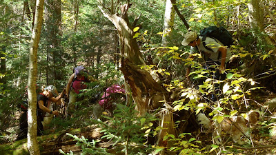
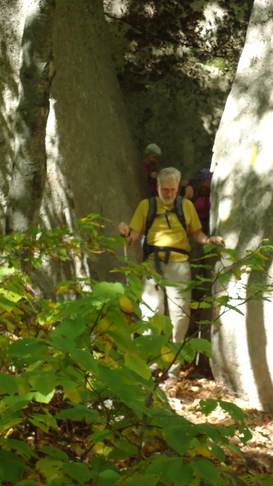
Moving more slowly now, as the grade steepens, and the spruce and balsams are getting thick and tight-together amidst the crisscrossed deadfall trees, I stop and wait for the others. Ralph is right behind me, and then Dorothy a few steps back; further down the slope, Marcelo keeps an eye on his wife Bev, and Ralph's wife, Blanca, and Kathy, who, quietly, slowly, yet seemingly effortlessly, ascends at the back of the group.

"So, I think if we head this way," I tell them, "it's a little more... um..... open."
"Which way?"
"This way."
"That way?"
"That way."
So we go that way. I wrestle a thick dead log down to the ground, and then hack away all its little branches with my hands and follow that by crashing my body through the medium sized pieces that snap off with each step. There. Shortly after that short steep open section, we are closed in again by deadfall, and are traversing east trying to find a way past a giant spruce log. Ralph catches up to me and says that maybe we should think about lunch, as the others are talking about things like low blood sugar.

While the others eat, a hastily whack westward, to be sure that we haven't wandered off on the wrong tributary. Friday [my dog], who is right behind me, wishes we were stopping for lunch. Soon, I find the head of the brook in a cavernous gorge-like chip out of a sizeable scaur amidst the conifers; and despite my anxiety at not being at Goodrich Rock by now, I am momentarily pleased, as if finding the genisis of the water from this un-named Osceola brook, has suddenly calmed me, as it's a special place in these woods, a place where few people have been, and the trickling sylvan watermusic soothes my soul.
Then I look again at my map. Shoot! The head of the brook is beyond the Goodrich Rock! We've gone too far! I start heading back to the group, dreaming of soon seeing the rock hiding amidst the greenery of the conifer forest...
After lunch, during which time Ralph has broken out the compass, and Dorothy has broken out the altimeter, and Ralph also has a GPS, and there is much discussion as to where the elusive rock is; I stand up and announce that I'm pretty sure it's right down that way.
"That way?"
"That way."
We all seem to agree. Having stayed alongside the brook for too long, I figure we're northwest of it. We are soon stumbling down the steep-nested rocks and rootclumps, heading southeast. Another reason I'm sure that we've gone too high, is that on one of my scouting missions, while the others took a break, I hiked until I saw the ridge, with the blue blue sky as a serene backdrop to the wind-fluttered yellow birch leaves, and the usual fungal accompaniment beneath the hardwoods. Knowing that Goodrich Rock sits in a den of conifers, similar to the one we're now tramping through, I am sure we've gone to far. If we went over the ridge, we'd begin descending down to Timber Camp... hmmm... sounds interesting.... another day maybe...
 Leading the way, somewhat hastily, we are now descending, our group-line spreading out somewhat, as the going is more open, easier, and with each step I scan the distances around me: uphill, downhill, and straight in front of me, saying to myself... where is it? it's got be right here... somewhere... but where is it?
And then Dorothy, cries out, "Is that it? That's it! There it is!"
and turning back up the hill, I see it, just some fifty feet down the hill. From below, the rock is an imposing tower-like feature; but from above, it is considerably more covert and
diminutive. I am astounded that I had just passed it without seeing it. We crown Dorothy and scale the ladder. After the climb up the ladder, the view we'd been waiting for greets us with a wide open countenance of blue above nature's forest quilt of reds, oranges and yellow amongst the green. Magnificent.  We made it. Halleluliah. Although never truly lost [I prefer the term temporarily misdirected], we were tested; and now, sitting peacefully at the top of the prodigious rock, we feel an elevated sense of accomplishment after the arduous bushwhack and the psychological fatigue of not knowing exactly where we were. We summarize that we missed the rock by about 200 feet as we hiked up.

Wednesday, October 5, 2011

Wilderness First Aid


Once again, the WVAIA is sponsoring a Wilderness First Aid Class. Instruction will be provided by Stonehearth Open Learning Opportunities (SOLO) of Conway, NH. The class will be held here in Waterville Valley.

WHEN: Saturday / Sunday
November 5th & 6th, 8:30 AM- 5:00 PM

COST: $125.00, WVAIA Members $100.00
WHERE: Brookside Room
For Info, Email: wvaiatrails@gmail.com

Thursday, September 29, 2011

Sept 24th Trails Day: The Mad River Trail


A small but enthusiastic crew [Gary Moak, Marianne Peckham, Barbara Forsberg and Dan Newton], set out around 8:15AM from the West Branch Road trailhead to clear the washdowns from the Mad River Trail. At right, they hoist one of several logs that were pasted against the shoreline where the West Branch Footbridge abutment once used to be.


The WVAIA chain saw made its first appearance in many moons, and the bow saws and pruning saws, loppers, and all hands on deck, made fast work of the tree debris.

In addition to the West Branch Footbridge that is out, there is a significant section of the trail that has been obliterated. The positioning of the trail on the outside of a turn [just above the WV "Town Beach" behind High Country condos], means a riverside trail will continually be vulnerable to high water damage. It may be decided to relocate the trail in this section.

Saturday, September 10, 2011

Greeley Ponds Trail Hit HARD by Hurricane Irene

[Click on photos to enlarge them]

The entire length of the Greeley Ponds Trail has been devastated by Hurricane Irene, but no place more so than the section before the Scaur Trail junction [see below], where the Mad River, having its course thrown off-stream by washed-out rocks and tree-debris, is draining into the Greeley Ponds Trail in several places, so that it is two or three feet deep in places, resembling a mountain brook, rather than our beloved hiking and X-C ski trail!

The following is a photojournal of sorts by Dan Newton, taken the week after the storm, while out assessing the trail with members of the White Mountain National Forest, the week after the big storm. At present, and for the foreseeable future, the trail is closed.


Beyond the worst of the flooding, the trail has been gutted by the raging torrent, so that its footbed is a rumble of rocks with no dirt. Except for the flooded-out sections before the Scaur junction, the rest of the entire trail looks more or less like the pictures below...

 
The Knight Bridge weathered the storm with no damage, but the bridge beyond it, between the Flume Brook Trailhead and the Kancamagus Brook Ski Trailhead, was partially destroyed. It's a steel-girder bridge, but it's jointed in the middle. The Flume Brook ripped it apart and washed one half of the bridge downstream, but the other half remains standing, as if oblivious to the destruction around it. The Flume brook has been redirected by the chaos; and so, the bridgehalf that remains spans a now dry brookbed.


The abutment remaining on the nearside of the bridge looks lonely and a little confused as it gazes out across the dry rocks...

Above the bridge, or what's left of it, the trees and rocks have been washed into a moutainous ridge of debris that redirects the brook, so that it flows over the topsoil above where the trail crosses the bridge.


At this point in my investigations, I left my companions, Jenny Burnett of the WMNF and four fireman from Maine, hired to help forge a path through the debris, and headed for the Flume Brook Trail, which I suspected was significantly affected. The report from Jenny is that the rest of Greeley Ponds Trail is "horror-ific." Rough estimates suspect that the trail will be closed for at least a year, and there has been talk of re-routing the trail... This is really hearsay at this point; so, stay tuned...

Meanwhile, I headed up the Flume Brook Trail. At the section which was always sort of "in" the brook for a few steps, the "few steps" are now more like 50 yards of trail wiped out by the brook. In the first picture below, the trail is at the upper righthand corner; and in the second photo, looking downtrail, you can see the trail on the lower left of the frame, and the rest of it--- gone.


After another short washout and a generally gutted-out trail, the pool in the flume at the trail terminus is guarded by a massive pile of washdown...
 

...and, the little round pool has been redesigned. The water obliterated the trail along the rock wall, and the HUGE stones we used to sit on, have been repositioned, so that the pool is now rectangular, and deeper. It's quite nice actually, a silver lining of sorts, after all the devastation...


Thursday, August 11, 2011

AUGUST 6TH HIKE: TIMBER CAMP


[Click on photos to enlarge them]


A large and enthusiastic group of hikers headed off to Timber Camp and beyond, guided by two able WVAIA hike leaders, Gary Moak and Dan Newton. On the way, they heard the story of a small sparrow of some kind, whose nest was unexpectedly found, the previous week, next to a water-bar just below the Timber Camp kiosk. At the time, there were four red freckled eggs in the nest. One would like to think that all four flew the nest to young adulthood, but can't help but wonder, why did she build her nest in the ground? We have our research staff looking into this, but if anyone out there knows why, feel free to let us know...


The time of year did not grace us with a plethora of wildflowers or mushrooms; however, we saw several species of clubmoss, the dissembling fern allies that look like moss but aren't; such as, Staghorn Clubmoss, Shining Clubmoss, or Ground Cedar Clubmoss [pictured below]


Other nefarious species [pictured below], were seen, but not identified...


Hikers at the stone bench beyond Timber Camp enjoyed a fabulous view of Painted Cliff [below and right], the sheered-off eastern edge of East Osceola. From the same vantage point, two other cliffs were seen: K1 and K2 on the western side of Mount Kancamagus; and, north through the Mad River Notch, the expansive cliffs on Mount Huntington.


Wednesday, August 3, 2011

Galehead Hike


A COOL CLOUDY DAY ON GALEHEAD
JULY 3OTH, 2011
Left to right: Gary Moak, Samir & Nadia Kassissieh, and Dan Newton 

Despite the forecast of clearing skies, the mountains remained blanketed in a wet fog-like cloudscape, as if they were holding onto the brief bit of rain they'd received the night before. The rocks were slippery, the conversation lively, and all enjoyed a relaxing lunch at the hut. 


Sunday, July 31, 2011

JULY 16TH TRAILS DAY FELLS PLENTY OF TIMBER ON THE TIMBER CAMP TRAIL


Overgrowth at the hairpin turn was no match for the tenacious crew. The trail, a delightful strolling amble up the foothills of East Osceola, will be in fine shape for the upcoming WVAIA hike, August 6th. This hike, with two leaders, offers the option, for those who are feeling adventurous, of continuing past the terminus of the trail on a unique extended ramble up a bootleg trail to a great view of four different cliffs, as you sit on a stone bench and watch the breeze filter through the leaves of the paper birch trees...

A MUST hike for anyone who thought they'd been everywhere on the Waterville Valley trail system! To register, email us at wvaiatrails@gmail.com.

Click on the images to enlarge them

The day's crew: Mike and Claudia Connelly [left]; and, Gary Moak and Brenda Conklin [right]. Photograph by Dan Newton
Next Trails Day: September 24th

Thursday, July 28, 2011

Croquet with the WVAIA: Sundays at 3:00PM

The historic association between the WVAIA and local Croquet enthusiasts, which began sometime in the late 1800's, is still hitting it through the wickets in 2011. The WVAIA sponsors the Sunday gatherings and invites all who are interested to come and watch and/or play. The friendly, casual and relaxing Sunday afternoon atmosphere is a perfect way to wind down after a long weekend hike.

Click on the photos to enlarge: 

The discerning crowd looks on as....

Resident expert, Jim Hamlin, shows us how it's done.

Mike Kater lines one up


Russ Carlise, our leader, aiming for two shots